What is the geographical significance of Mesopotamia?
Mesopotamia, meaning land between two rivers, refers to the region between the Tigris and Euphrates. Its fertile crescent provided an ideal environment for early agriculture, enabling sedentary lifestyles and the growth of complex societies. This unique geography fostered advancements in irrigation, urban planning, and trade, making it the Cradle of Civilization where many foundational human innovations first emerged. Understanding its geography is key to comprehending early human development.
Where was the ancient civilization of Sumer located?
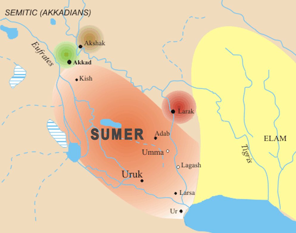
The ancient civilization of Sumer was located in the southernmost part of Mesopotamia, primarily within what is now modern-day southern Iraq. Situated on the alluvial plains fed by the Tigris and Euphrates rivers, Sumerian city-states like Ur, Uruk, and Eridu flourished due to the fertile soil and abundant water resources. Its geographical position was crucial for agricultural productivity and strategic trade routes, allowing it to become a cradle of urban development and early civilization.
What major rivers flowed through Sumer?
Sumer was profoundly shaped by the Tigris and Euphrates rivers. These two vital waterways originated in the Anatolian highlands and flowed southeast through Mesopotamia, converging before reaching the Persian Gulf. The rivers provided essential water for irrigation, supported fertile agricultural lands, and served as crucial transportation arteries for trade and communication among Sumerian city-states. Their presence was fundamental to the rise and sustenance of Sumerian civilization, defining its geographical boundaries and economic life.
Which modern countries occupy ancient Mesopotamia?
Modern-day Iraq encompasses the vast majority of ancient Mesopotamia, particularly the region where Sumerian civilization developed. Additionally, parts of ancient Mesopotamia extended into present-day Kuwait, eastern Syria, southeastern Turkey, and southwestern Iran. These contemporary nations now hold the historical sites and remnants of this influential region. Understanding this modern geographical context helps connect ancient history with the current geopolitical landscape, offering a tangible link to the past for global audiences.
How did geography influence Sumerian city-states?
Sumerian city-states were profoundly influenced by geography, primarily the Tigris and Euphrates rivers. Their location on fertile plains facilitated extensive agriculture through irrigation, allowing populations to grow. Cities were built near river channels for water access, trade, and defense. The open, flat terrain also led to conflicts over resources and the development of fortifications. Geographical features dictated settlement patterns, economic strategies, and political interactions, making the environment a critical factor in Sumerian societal evolution and the strategic placement of urban centers.
Map of Mesopotamia Sumer, Ancient Sumer locations, Where is Sumer today, Historical geography Mesopotamia, Sumerian civilization map, Tigris and Euphrates rivers mapExplore the ancient geography of Mesopotamia and Sumer with a detailed map guiding you through its historical landscape. Uncover the crucial river systems, fertile crescent regions, and prominent city-states that defined this cradle of civilization. This comprehensive guide provides U.S. searchers with essential navigational insights into where Sumer was located, its modern-day equivalents, and how its geographical features profoundly shaped early human history. Discover the vital roles of the Tigris and Euphrates rivers, the strategic importance of cities like Ur and Uruk, and understand the cultural impact of this pivotal region. Dive deep into the historical map to grasp the immense legacy of Sumerian advancements, from writing to complex societal structures, all driven by its unique geographical positioning. Gain clarity on the physical boundaries and significant settlements of this foundational civilization, offering a precise visual and textual journey through one of humanitys most influential historical periods.
- Where is Mesopotamia located on a modern map? - Mesopotamia primarily covers present-day Iraq, with its historical reach extending into parts of Syria, Turkey, Kuwait, and Iran. The ancient region was defined by the Tigris and Euphrates rivers, which still flow through these territories today. Understanding its modern geographical context helps pinpoint ancient sites and their contemporary locations, providing a tangible link to a pivotal era of human history.
- What rivers are central to the geography of Sumer? - The Tigris and Euphrates rivers are absolutely central to Sumerian geography. These twin rivers provided the fertile soil and essential water for irrigation that allowed Sumerian civilization to flourish in southern Mesopotamia. Their consistent flow enabled agriculture, supported dense populations, and served as critical routes for trade and communication among the city-states, directly shaping the regions development.
- Which major cities were part of ancient Sumer? - Ancient Sumer included prominent city-states such as Uruk, often considered the worlds first true city, known for its monumental architecture. Other significant centers were Ur, a major port and religious hub, and Eridu, believed to be the earliest Sumerian city. Lagash and Umma were also influential, frequently engaged in conflicts over resources. These cities formed the vibrant core of Sumerian civilization.
- Why is Sumer called the Cradle of Civilization? - Sumer is dubbed the 'Cradle of Civilization' due to its pioneering innovations that laid the foundation for complex human societies. Here, early forms of writing (cuneiform), organized government, advanced irrigation systems, monumental architecture (ziggurats), and the wheel emerged. Its geographical advantages in the fertile crescent, supported by the Tigris and Euphrates rivers, fostered an environment conducive to these transformative developments, profoundly impacting global human progress.
- How did Sumerian geography influence their economy? - Sumerian geography, centered on the fertile Tigris and Euphrates floodplains, profoundly shaped their economy. Abundant water and rich soil enabled surplus agricultural production, particularly barley and wheat. This surplus supported specialized labor and trade. River systems facilitated transport of goods, fostering extensive commercial networks with neighboring regions for materials Sumer lacked, like timber and metals, making geography vital for economic prosperity and societal complexity.
- What is the historical significance of Sumer on a map? - The historical significance of Sumer on a map lies in its representation as the birthplace of urban civilization. It visually demonstrates how complex societies, with advanced agriculture and city-states, first arose in a specific geographical context. The map reveals the strategic positioning of cities, the reliance on river systems, and the dense population centers that contributed to groundbreaking innovations in governance, technology, and culture, influencing subsequent civilizations across the world.
The historical region of Mesopotamia, often heralded as the Cradle of Civilization, offers a profound journey into humanitys earliest urban societies and technological innovations. Central to this rich tapestry is Sumer, an ancient civilization that emerged in the southern part of Mesopotamia. Exploring a map of Mesopotamia and Sumer provides crucial insights into how geography influenced the development of writing, mathematics, law, and monumental architecture. For U.S. audiences seeking to comprehend this foundational period, understanding the precise locations and topographical features depicted on these maps clarifies the environment that fostered such significant advancements, drawing a vivid picture of human ingenuity amidst challenging yet fertile landscapes.
Delving into the geographical layout of Sumer reveals its intrinsic connection to the Tigris and Euphrates rivers. These vital waterways were not merely sources of life-sustaining water but also served as critical arteries for transportation, trade, and the annual agricultural cycles that sustained large populations. A detailed map highlights the intricate network of irrigation canals that Sumerian engineers skillfully constructed, transforming arid plains into highly productive farmlands. This hydrological engineering feat underscores the deep understanding and manipulation of their environment, directly impacting settlement patterns and the strategic importance of various city-states within the region, making the map an essential tool for historical comprehension.
For those navigating the complexities of ancient history, visualizing the map of Mesopotamia Sumer demystifies many historical narratives. It showcases the strategic positions of legendary cities like Ur, Uruk, and Lagash, illustrating why these centers flourished and became epicenters of cultural and political power. Furthermore, maps help contextualize the constant interplay between these independent city-states, often driven by access to resources and control over fertile lands. By examining these ancient maps, contemporary learners gain a deeper appreciation for the geopolitical dynamics that shaped one of the worlds first great civilizations, offering a robust educational experience that transcends mere dates and names by providing a tangible spatial context.
Historical Geography of Mesopotamia and Sumer
Where is Ancient Mesopotamia Located Today
Ancient Mesopotamia, a historical region nestled in the Fertile Crescent, corresponds largely to modern-day Iraq. However, its expansive territory also encompassed parts of contemporary Kuwait, Syria, Turkey, and Iran, particularly along the Tigris and Euphrates river systems. The southern portion of this region was home to Sumer, the earliest known civilization in Mesopotamia, situated primarily in what is now southern Iraq. For students and enthusiasts in the U.S., identifying these modern geographical markers on a map helps bridge the gap between ancient history and current geopolitical landscapes, offering a tangible connection to a civilization that laid the groundwork for many aspects of our modern world. Visualizing these locations transforms abstract historical facts into concrete geographical realities.
Understanding the exact coordinates of ancient Mesopotamia involves tracing the paths of the Tigris and Euphrates, rivers that remain vital to the regions ecology and economy today. These rivers flow southeastward from the Anatolian highlands, converging before emptying into the Persian Gulf. Sumerian cities like Ur and Uruk were strategically positioned near these waterways, maximizing access to water for irrigation and facilitating trade routes that connected them to distant lands. Modern maps show how these ancient riverbeds and their surrounding floodplains continue to influence settlement patterns and agricultural practices in Iraq, illustrating a continuity of geographical significance that has persisted for millennia. This continuous relevance makes the study of Mesopotamias ancient map particularly insightful for understanding long-term human-environment interactions.
For those researching or traveling to the region, locating ancient Mesopotamian sites on contemporary maps is crucial for planning and appreciation. Many archaeological sites from the Sumerian period are actively being excavated and preserved within Iraq, providing invaluable historical data and tourist attractions. Although political conditions can sometimes impact accessibility, the geographical identification of these ancient territories on a map remains a fundamental starting point for any exploration. This modern-day geographical context helps solidify the understanding of Sumers historical significance, enabling U.S. audiences to truly grasp the scale and impact of this ancient civilizations contributions to global heritage by pinpointing its exact contemporary location.
Key Rivers and Regions of Sumer
The twin rivers, the Tigris and Euphrates, are undeniably the lifeblood of Mesopotamia and specifically Sumer. Originating in the mountains of Turkey, these rivers flow through Syria and Iraq, forming the fertile alluvial plain where Sumerian civilization thrived. The Tigris, generally faster and prone to more unpredictable flooding, provided a robust eastern boundary, while the Euphrates, slower and meandering, was more amenable to extensive irrigation networks. The strategic interplay between these two rivers defined the agricultural success and settlement patterns of Sumer, enabling the sustained growth of complex urban centers by providing consistent water for crops and a reliable means of transportation for goods and people across the vast region.
Beyond the major rivers, Sumer comprised several distinct geographical regions, primarily the vast, fertile plains of southern Mesopotamia. This low-lying marshy delta region, where the rivers eventually converged, offered incredibly rich soil deposited by annual floods, ideal for growing staple crops like barley and wheat. However, this fertility came with challenges, including managing floods and saline soil. Sumerian ingenuity in developing sophisticated irrigation and drainage systems allowed them to harness these natural forces, transforming potentially hostile environments into agricultural powerhouses. Understanding these regional distinctions on a map helps explain the localized development and unique characteristics of individual Sumerian city-states, each adapted to its immediate microenvironment.
Key regions within Sumer included the southern wetlands, the central plain, and the areas bordering the Persian Gulf. Cities like Ur, Uruk, and Eridu were established in strategically important locations, often near river branches or on slightly elevated ground to mitigate flood risks. The map vividly displays how these cities were interconnected by a network of canals and trade routes, facilitating the exchange of goods, ideas, and cultural practices across the region. This geographical understanding is paramount for grasping the economic engine that powered Sumerian society, demonstrating how the careful management of its natural resources, especially water, was central to its unprecedented growth and enduring legacy as one of humanitys pioneering civilizations.
Understanding Sumerian Civilization Map
Major Sumerian City-States and Their Locations
The map of ancient Sumer is dotted with numerous city-states, each a powerful, independent entity with its own rulers, deities, and administrative systems. Among the most prominent were Uruk, often considered the worlds first true city, famous for its massive ziggurats and early forms of writing. Ur, another significant city, was a thriving port on the Euphrates, renowned for its royal tombs and advanced metallurgical skills. Lagash and Umma were frequently in conflict over fertile land and water rights, highlighting the geopolitical complexities of the era. Eridu is often cited as the earliest Sumerian city, believed to be founded by the gods themselves, reflecting its profound religious significance. These cities were not merely settlements but vibrant centers of trade, culture, and innovation, whose precise locations on a map provide essential context for their historical roles.
Locating these major city-states on a historical map allows for a deeper understanding of their strategic importance and interrelationships. Uruk, situated on a former channel of the Euphrates, commanded a vast agricultural hinterland. Ur, positioned closer to the Persian Gulf, capitalized on maritime trade routes that extended across ancient waterways. Nippur, though not a political capital, held immense religious authority as the seat of the god Enlil, making it a crucial pilgrimage site. The spatial distribution of these cities, often positioned along the rivers or irrigation canals, underscores the critical role of water access in their establishment and prosperity. For U.S. learners, visualizing these locations helps paint a clearer picture of ancient urban planning and regional power dynamics, emphasizing how geography dictated development.
A detailed map also reveals the relative proximity and distances between these powerful urban centers, explaining patterns of alliances, conflicts, and cultural diffusion. For instance, the frequent clashes between Lagash and Umma over the Gu'edena (a fertile border territory) are best understood when their close geographical placement is observed. Similarly, the influence of larger cities like Uruk and Ur often extended to smaller neighboring towns, creating spheres of economic and political dominance. Mapping these ancient city-states provides a dynamic framework for interpreting Sumerian history, offering a tangible visual aid that grounds complex historical narratives in specific geographical realities. This geographical perspective is indispensable for anyone seeking a comprehensive understanding of the first urban civilization.
- Uruk: Often considered the first true city, known for monumental architecture and early writing.
- Ur: A major port city and religious center, famous for its ziggurat and royal cemetery.
- Lagash: A powerful city-state frequently at odds with Umma over land and resources.
- Nippur: A significant religious center dedicated to the god Enlil, holding immense spiritual authority.
- Eridu: Believed to be the earliest Sumerian city, holding deep mythological and religious importance.
- Kish: An early important city, known for its powerful kings and significant archaeological finds.
What Does the Map of Sumer Reveal About Its Society
The map of Sumer offers profound insights into the organizational structure and societal priorities of its ancient civilization. The dense concentration of urban centers, often fortified and strategically placed along waterways, indicates a highly organized society focused on collective defense and resource management. The intricate network of irrigation canals, visible through historical reconstructions, reveals a sophisticated understanding of hydraulic engineering and a societal commitment to large-scale infrastructure projects. This investment in public works suggests a centralized authority capable of coordinating labor and resources on an impressive scale, a hallmark of early state formation. These geographical details on the map directly reflect the advanced administrative capabilities that defined Sumerian society, from water distribution to defense planning, illustrating a complex societal hierarchy.
Furthermore, the map highlights the importance of trade and economic interaction within Sumer and with neighboring regions. The positioning of cities near river access points and major routes indicates their role as hubs for the exchange of goods, both agricultural surpluses and imported raw materials. This economic activity fostered specialized labor and a diverse social stratification, from merchants and artisans to farmers and priests. The geographical layout suggests a society driven by resource acquisition and commercial enterprise, demonstrating how trade networks facilitated cultural exchange and technological diffusion. For a U.S. audience, this geographical analysis underscores the foundational economic principles that emerged in Sumer, showcasing an early model of market-driven interactions that echo in modern economies.
Finally, the map of Sumer profoundly illustrates the integral relationship between humanity and its environment in ancient times. The Sumerians ability to thrive in a challenging, semi-arid environment, transforming it into an agricultural breadbasket, speaks volumes about their resilience, innovation, and adaptive capacity. The geographical constraints and opportunities presented by Mesopotamia directly shaped their religious beliefs, political structures, and technological advancements. Studying this map allows one to appreciate how a civilizations physical setting can profoundly influence its cultural identity and societal evolution. It underscores that human civilization is not merely an abstract concept but a tangible outcome of intelligent interaction with a specific geographical context, providing an invaluable lesson in historical ecology for contemporary learners.
Mesopotamia map current location, Sumerian city states map, Tigris Euphrates river map, Ancient Sumer civilization geography, Cradle of Civilization map, Where was Sumer found


SUMER1 Ancient Mesopotamia Map SUMER1 The Rise Of Cities Personal Identity Safety And 15299 Sumer Elam Subartu LWDWO Il 1080XN 3909501842 P97X 1080XN 3909501842 P97X 740 Sumerian Civilization Stock Vectors Vector Art Shutterstock Sumerians State Region Anatolian Colonies In Antiquity 2521434111 History Definition Summary OFF D2D7DC5AB7DD4E7F8CC7ED183642E5CE Students Britannica Kids Homework Help 277565 004 747378BA 277565 004 747378BA World Timelines Maps A28496CBDD64E03F8E36FE969B2C72A1 Civilizations Geography A32054CE46076911BA0168D47880D165 Kingdoms Kutha Kutu MAPSUMER01 Full MAPSUMER01 Unit Early Humans Ms K S Social Sumeria Neo Empire Story Birth Is Unveiling Land 06c836c3bfb19c1b601eb00c97ad7cc6.


Sumer Ancient Mesopotamia Map Wikipedia CTMLAE How Did Become The Cradle Of Civilization SUMER9 MAP2 SUMER9 MAP2 Charting Mesopotamian World Unraveling Secrets B2F866F752E36A483C1345C82B705781 Humanities Libretexts 4508F48EF54AA33A222DB12EB11F125C1DE4F77C Definition Simple Que Veut Dire M Sopotamie WNZCUJ Labeled Storia SUJL Bible Odyssey Rm G A Sumerian Scrolller 12rbhshl25 City States And Deities In 2025 9fa11bbf7a49e4b2baecf89abb312f63 Le Pays De L Histoire Commence DEIYSP Southern.


Megoszt S Comment Completed And Colored In Mesopotamia Map Sumer Ancient Civilization Worksheet By Ace Up Your 750F 14440909 750F 14440909 Figure From Were There Sumerians 001 Khan Academy 34CD6F5FDDE7FA00A16489A700D82D84F84C29EF On World Free Printable Smarthistory West Asia Cradle Of Images Picstank Com Stock Vector Turkey The Ottoman Dynasty States 1250927953 Maps 1162564 Orig 1162564 Civilizations Empires Brain Chamber Pin 0e87ceb37d54bb1b4e9210460f8784b0 Geography Activity For More Low Prep Print Original 4561813 Mesopotamian Cartography Aegean F33725E455A8307A8A1A473C241151BE.