Discover comprehensive US territory maps designed for American audiences seeking clear geographical insights. This guide helps you understand the various US territories, their locations, and why these maps matter for travel, business, or educational purposes. Learn how to locate accurate, up-to-date maps online or through local government resources. We break down what makes a territory distinct from a state, offering essential information for anyone planning to visit or conduct operations within these areas. Whether you are researching for a school project, planning a trip, or looking for specific administrative boundaries, this resource provides practical steps. Find detailed information on where to acquire high-quality physical or digital maps, compare different map types, and understand crucial details before making decisions. Our goal is to equip you with the knowledge to confidently navigate and explore the United States insular areas and other territories. Consider map reviews and availability near you to select the best option for your specific needs, ensuring you have reliable data at your fingertips.
- What is the largest US territory by population? - Puerto Rico stands as the largest US territory in terms of population. With millions of residents, it significantly influences US demographics and cultural landscapes. Its distinct political and economic ties to the mainland United States make it a prominent insular area. Maps often highlight its status and geographical significance.
- Are residents of US territories US citizens? - Most residents born in major US territories, such as Puerto Rico, Guam, and the U.S. Virgin Islands, are indeed US citizens. However, their citizenship often differs from that of state-born citizens in terms of federal voting rights. American Samoa residents are US nationals but not automatically citizens.
- How many official US territories are there? - The United States currently oversees 14 territories, but only 5 of these are permanently inhabited and widely recognized: Puerto Rico, Guam, U.S. Virgin Islands, American Samoa, and the Northern Mariana Islands. The other nine are uninhabited minor outlying islands with strategic importance. Maps often focus on the populated areas.
- Can I buy a physical map of all US territories? - Yes, you can purchase physical maps that display all US territories. Reputable map retailers, specialty bookstores, and government agencies often carry such maps. These can range from large wall maps to smaller, more detailed atlases. Online searches like 'buy US territory map' will show many options.
- Do US territories have their own governments? - Most major US territories have their own democratically elected governments, allowing them a degree of self-rule. While they adhere to US federal laws, they also enact their own local laws and regulations. This dual governance structure is a key feature differentiating them from US states.
- What is an 'unincorporated' US territory? - An 'unincorporated' US territory means it is governed by the US Congress but not fully integrated into the US constitutional system. Most US territories fall under this category, including Puerto Rico and Guam. This status affects local rights and federal oversight, often visible on political maps.
- How do US territory maps help with local travel? - US territory maps are invaluable for local travel planning, helping identify roads, attractions, and services. They provide essential navigational details for exploring unique landscapes and cultures. Interactive digital maps offer real-time directions and local business information, enhancing the traveler's experience and making it easier to find places 'near me'.
What are the main US territories?
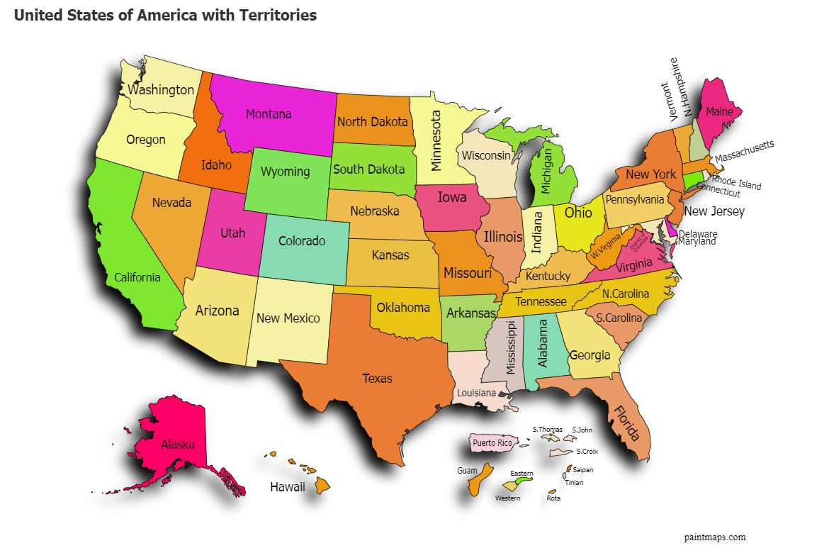
The United States officially administers several territories. The largest and most populous include Puerto Rico, Guam, the U.S. Virgin Islands, American Samoa, and the Commonwealth of the Northern Mariana Islands. These areas are under US sovereignty but are not states, each holding a distinct political status with varied levels of self-governance. Maps clearly delineate their locations and boundaries.
How do US territories differ from states?
US territories differ from states primarily in their political representation and constitutional status. While most territorial residents are US citizens, they generally lack full voting representation in the US Congress and cannot vote in presidential elections. Territories are governed by federal law but maintain varying degrees of local self-rule, unlike states which are fully integrated into the federal system.
Can US citizens travel freely to US territories?
Yes, US citizens can generally travel freely to US territories without requiring a passport, much like traveling between states. These territories are considered part of the domestic travel zone. However, it's always wise to carry a government-issued photo ID. Customs checks are typically not performed, making travel to these destinations straightforward for American citizens.
Where can I get a detailed map of Puerto Rico?
Detailed maps of Puerto Rico are available from several reliable sources. The US Census Bureau provides official geographical data. You can also find high-quality maps from reputable online map retailers, educational publishers, and dedicated cartography services. Interactive digital maps are also accessible via Google Maps or similar platforms for specific navigation and points of interest.
Why is understanding US territory boundaries important?
Understanding US territory boundaries is crucial for legal, administrative, and practical reasons. It clarifies jurisdictions for business, determines voting rights, and impacts travel regulations. Accurate maps help individuals and organizations navigate specific laws and cultural norms unique to each territory. This knowledge prevents errors in planning, research, and general engagement with these distinct American regions.
What Are US Territory Maps Used For?US territory maps serve as crucial tools for understanding the geographical and political scope of the United States. These maps extend beyond the 50 states, illustrating regions under American sovereignty but not integrated into the state system. They are essential for a wide range of uses, from academic research and government planning to travel and business development across these unique areas. Americans frequently seek these maps to grasp the full extent of their nation's reach.
Understanding these territories is important for citizens. They include places like Puerto Rico, Guam, the U.S. Virgin Islands, American Samoa, and the Northern Mariana Islands. Each holds a distinct relationship with the federal government, impacting everything from voting rights to economic regulations. Accurate mapping provides clarity on these varied relationships, offering a visual guide to America's diverse political landscape.
Many people use these maps to plan trips, understand historical contexts, or even prepare for business ventures. Knowing the specific boundaries and designations helps prevent misunderstandings about legal status, local governance, and cultural differences. This guide will walk you through what US territory maps represent, how to find them, and what factors to consider when using them effectively.
Understanding US Territory Maps
US territory maps distinctly show regions governed by the United States that are not states or parts of states. These areas are administered by the US federal government, yet they often have a degree of self-governance. The legal status of each territory varies significantly, creating a complex but interesting aspect of American geography. These differences are clearly outlined in specialized maps.
The term "territory" itself carries specific legal implications. Residents often hold US citizenship, but they typically cannot vote in federal elections like presidential contests. Maps clarify these unique political boundaries, helping users understand where these specific rules apply. It is important to distinguish between organized and unorganized territories, and incorporated versus unincorporated territories, as these classifications impact local rights and federal oversight.
Many online and physical resources offer these maps. Users can find them on government websites, educational platforms, and through specialized cartography services. The precision of these maps assists researchers, travelers, and businesses in navigating the unique legal and social structures of each region. Accessing current information helps ensure any decisions are based on accurate data.
What Defines a US Territory?
A US territory is a subdivision of land under the jurisdiction of the United States, but not part of any state. These areas are typically governed by federal law, though they often possess their own local legislative bodies. The relationship between the federal government and its territories has evolved throughout American history, shaping the unique status of each one today. Current maps reflect these established designations.
The key characteristic distinguishing a territory from a state is its lack of full constitutional integration. While residents of many territories are US citizens, they do not have full voting representation in the US Congress. This status impacts local economies, federal funding, and the everyday lives of inhabitants. Maps visually present these separate yet connected jurisdictions, offering crucial geographical context.
Understanding this definition is essential for anyone dealing with these regions, whether for travel, trade, or policy studies. Detailed maps often include administrative lines, capital cities, and key geographical features of each territory. These visual aids simplify what can be a complex legal and political topic, helping users quickly grasp the fundamental arrangement.
Why Do US Territory Maps Matter for Americans?
US territory maps hold significant relevance for American citizens, providing a complete picture of the nation's reach and influence. They allow individuals to understand the full scope of American governance, including regions with unique legal and political arrangements. For those interested in national policy, defense, or international relations, these maps are indispensable resources that highlight areas of strategic importance.
For travelers, these maps are vital planning tools. They identify destinations like the Caribbean islands of the US Virgin Islands or the Pacific paradise of Guam, showing their relation to the mainland. Understanding the geography and local divisions helps visitors navigate and appreciate the distinct cultures and environments found in each territory. Checking current map versions helps ensure smooth travel.
Businesses and investors also rely on accurate territory maps. These maps help in identifying markets, understanding regulatory environments, and planning logistical operations. Knowing the precise boundaries and administrative centers can significantly impact decision-making, ensuring compliance and maximizing opportunities within these distinct economic zones. Many services can be found with local map searches.
How to Use US Territory Maps Effectively
Using US territory maps effectively requires more than just glancing at land masses; it means understanding the layers of information they present. Begin by identifying the specific type of map you need, whether it is for general geography, political boundaries, or detailed demographics. Each map offers unique data points that can be more useful depending on your purpose. Many online platforms allow users to customize map views.
When reviewing maps, pay attention to the legends, scales, and any accompanying textual information. These details provide context for the visual data, explaining symbols, colors, and specific designations for each territory. Cross-referencing information with official government sources or reliable academic institutions can further enhance your understanding and confirm accuracy. This ensures you are working with the most dependable information available.
For local search intent, leverage digital maps with features like "near me" or "directions." If you are seeking services or locations within a territory, using these interactive map functions can guide you directly. Always check the publication date for any map you use to ensure it reflects current political and geographical realities, especially for regions that might experience boundary adjustments or administrative changes.
Where Can I Find Accurate US Territory Maps?
Finding accurate US territory maps is crucial for reliable information. Official sources often provide the most precise data. Government websites, such as those from the US Census Bureau, the Department of the Interior, or the National Geospatial-Intelligence Agency, are excellent starting points. These sites frequently offer downloadable digital maps or interactive tools detailing territorial boundaries and features.
Educational institutions and reputable mapping companies also produce high-quality territory maps. University libraries or geographical departments often have extensive collections, and commercial mapmakers often provide specialized versions. When choosing a map, look for clear indications of the source and revision dates to ensure its credibility and timeliness. Reviews can also guide you to the best options.
Online platforms like Google Maps or other reputable digital atlas services can provide interactive views, allowing you to zoom in on specific territories. While convenient, always verify information against official sources for critical applications. Many local map services can also provide localized information for specific territorial areas, including business locations and service availability.
What to Compare When Choosing a US Territory Map?
When selecting a US territory map, comparing several key factors helps ensure you pick the best one for your needs. First, consider the map's scale and detail level. A general overview map might suffice for basic understanding, but a detailed map is essential for specific research or navigational purposes within a territory. Check if it includes local roads, cities, and specific administrative divisions.
Next, evaluate the map's currency. Political boundaries and names can occasionally change, so using an up-to-date map prevents misinformation. Look for the publication or revision date. Also, compare the map's format: physical maps are great for wall displays or fieldwork, while digital interactive maps offer zooming capabilities, search functions, and integration with GPS for real-time navigation.
Finally, assess the map's source and purpose. Is it from a government agency, a commercial cartographer, or an educational publisher? Each source may prioritize different types of information. Read reviews to gauge user satisfaction and accuracy. For example, a map focused on tourism might highlight attractions, while a political map emphasizes electoral districts. Consider reviews for businesses providing map services near you.
Common Mistakes to Avoid with US Territory Maps
A common mistake when using US territory maps is assuming uniformity among all territories. Each US territory, such as Puerto Rico or Guam, has its own unique legal status, governance structure, and cultural identity. Treating them all as identical can lead to misunderstandings in travel planning, business ventures, or academic research. Always consult specific details for each territory.
Another pitfall is relying on outdated maps. Political boundaries, infrastructure, and even names can change over time. Using an old map might provide inaccurate information, which can have significant consequences, especially in legal or logistical contexts. Always check the publication or revision date of a map to ensure it reflects current realities. This is a simple step to prevent major errors.
Lastly, avoid neglecting the map's legend and supplementary information. The legend explains symbols, colors, and specific designations that are crucial for correct interpretation. Skipping this step can lead to misreading geographical features or political distinctions. Thoroughly reviewing all accompanying details ensures you fully understand the map's message and can make informed decisions. Many local map providers can offer consultation.
Related Terms and Local Context for US Territory Maps
Understanding US territory maps often involves encountering related terms that clarify the distinctions. Concepts like "insular areas," "commonwealths," and "unincorporated territories" are frequently used. An "insular area" broadly refers to any US territory not part of the fifty states. "Commonwealths" like Puerto Rico and the Northern Mariana Islands have a special relationship with the US, often with greater self-governance. "Unincorporated territories" are generally not intended for statehood and are not fully integrated into the US constitutional system. Grasping these terms enriches your understanding of the maps.
From a local context perspective, US territory maps become particularly useful for finding specific services or points of interest. If you are in the US Virgin Islands, for example, a detailed map can help you locate local businesses, tourist attractions, or government offices. Searches like "US Virgin Islands map reviews" or "Puerto Rico services near me" become highly relevant, connecting geographical data with practical needs. The availability of local maps, whether physical or digital, influences how easily one can navigate and access resources within these areas.
For many residents and visitors, understanding the local impact of federal laws versus territorial laws is crucial. Maps often delineate administrative boundaries that clarify which governmental body has jurisdiction. Checking local map reviews can also help you find the best map for practical navigation, including details on roads, public transport, and essential facilities. This blending of broad governmental structure with specific local utility makes US territory maps an invaluable resource.
When to Contact a Provider or Visit a Location for US Territory Maps
If you need highly specialized US territory maps, or require assistance with custom mapping solutions, contacting a professional map provider is often the best course of action. Specialized cartography services can create maps tailored to unique specifications, such as detailed topographical data for specific islands or precise boundary overlays for legal purposes. They can also offer expert advice on the best map types for complex projects.
Visiting a local map store or a government mapping agency's office can be beneficial for physical maps or for direct consultations. This allows you to view map quality firsthand, discuss your needs with knowledgeable staff, and potentially access maps that are not readily available online. You can inquire about the latest editions, specific regional details, and even historical maps for research. Check their hours and directions before you visit.
For general information or to purchase standard maps, online retailers and official government websites are usually sufficient. However, for large-scale projects, educational institutions, or businesses requiring frequent and accurate territorial data, establishing a relationship with a dedicated map provider can ensure ongoing access to up-to-date and reliable resources. Always compare pricing and availability before committing to a service.
US territory definitions, find US territory maps, American insular areas explained, official US territorial boundaries, how to use territory maps, compare US territory data, mapping US commonwealths, where to buy US territory maps


Interactive US Map With States And Capitales 2026 TechGEO Mapping Us Map 1320x754 . Maps Of The Month January 2026 By Miguel Garc A Lvarez 53bad5ca 75bd 4f73 A349 1200x896 . US Territory Map US Territories Map Territories Of The United States Us Territory Map . Map Of U S Territories Us Territories Exclusive Economic Zones . What Are The US Territories Answers Map Of The Us Territories 700x578




Updated Map Of The Usa Territories High Res Vector Graphic Getty Images Updated Map Of The Usa Territories . Interactive US Map With States And Capitales 2026 TechGEO Mapping F28e9d21 F517 4209 Bacc . Create Custom United States Of America With Territories Map Chart With Map Chart 228 . Map Of United States Territories States Territories Of An Alternate United States Of America Map With States And Territories Slide01 . Updated Map Of The Usa Territories High Res Vector Graphic Getty Images Updated Map Of The Usa Territories




U S States Territories Map Large 7410 11X17 1000 . US Territories R MapPorn Us Territories V0 . US State Capitals Map US Maps United States Territory Acquisition Map . United States Midterm Election 2026 The Year 2026 IMG 4624.webp. Here S Every State That Could Draw A New House Map By 2026 Dc118afa A9e4 454b 8e56 1144x872


USA Map Of The Year 2026 A Colorful Glowing Map Of The USA With The 1000 F 1754973914 . User Times Online Com Potts Potts Launches Updated 2026 Press Release 0531521 229093 . Map Of Us Territories Gadgets 2018 Us Territories Map . United States Map 2026 Neon A Neon Lit Map Of The United States With 1000 F 1754973883 . Map Of The Key Territorial Of The United States US Growth 1





The United Republics Of America 2026 R MapPorn . Territory Map March 2026 White Text V2 Tonnellerie Radoux Tonnellerie Territory Map March 2026 White Text V2 Scaled . Map Of The Usa 2026 Update TargetMap Header Meta V2 2 . Us Senate Elections 2026 2026 Senate Map . States Map Game Blank 2026 Senate Map


State Of The Map US Comes To Madison In 2026 State S Osm2026 . Introducing The 2026 Senate Interactive Map 270toWin Senate Incumbent . Exploring The United States Map What Defines Our Nation 960px 2026 United States Secretary Of State Elections Map.svg . Greenland US Territory Est 2026 Trump Shares New Map Of America Greenland Us Territory Est 2026 Trump Shares New Map Of America Including Canada Venezuela Greenland 16 9.webp. Greenland US Territory Est 2026 Trump Shares New Map Of America 2001554 Trump


Urbex Map USA 2026 Flash Sale MapUrbex Blog Image. 2026 Governor Map Prediction July 2023 YouTube . American Territories Map Wayne Baisey 35 Usa Territories . The United States Of America Territorial Expansion Vivid Maps Us Territory . Map Of The United States United States Showing The Growth Of The Map Of The United States United States Showing The Growth Of The Territory And The Border Of The States From The End Of The War Of In 1783 Until 1853 Color Lithograph Of The 19th Century American School